Your Cart is Empty

Zion National Park was one of our favorite stops on the entire #SwiftwickTrailTour. The thousand-foot sandstone cliffs, walking through a canyon, and breathtaking panoramic views made for an adventure of a lifetime.
Zion National Park is located in southern Utah and was carved by the Virgin River. The park is 15 miles long and hosts canyon walls that are 5000 ft above the canyon floor.
You will need a weekly pass or National Parks Pass for entry into the park. You don’t need a permit or reservation to visit most areas in Zion National Park with the exception of Angels Landing and hiking The Narrowsfrom the top-down (Chamberlain’s Ranch). Hiking the Narrows from the bottom-up (the hike we did) does not require a permit.
If you plan on hiking The Narrows, you’ll need to check the weather and flash flood potential as flow rates can change unexpectedly which can be extremely dangerous and cause closures.

The easiest way to get to The Narrows (from the bottom up) is to park in the Visitor Center and take the free shuttle all the way to the Temple of Sinawava. When the Visitor Center parking gets full (usually by 8 am -9 am) you can park in town and take the Springdale Line to the Visitor Center. Expect parking lots to be full and parking to be limited during peak season (April through September).
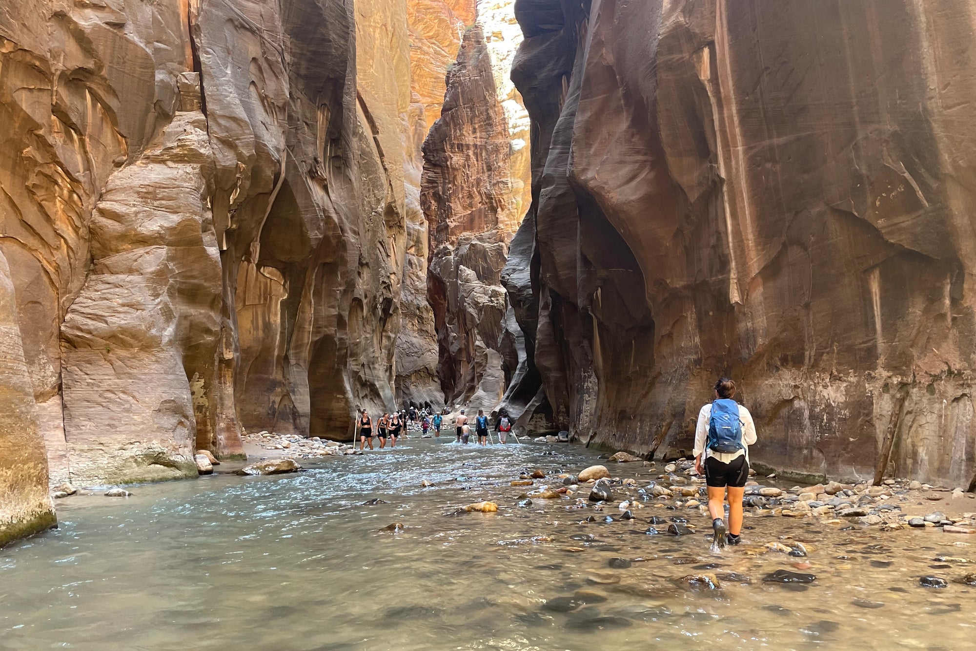
After a shuttle ride full of awe-inspiring views (and hilarious commentary from your bus driver if you get one like we did), you’ll make it to the last stop, the Temple of Sinawava. This is your last chance to fill up your water bottles and go to the restroom. From here, you’ll get off and hike along the river for about 1 mile until you hit the water. I hope you’re ready to get wet - it’s time to take a dip!

The water temperature was about 50-60 degrees while the air temperature was around 90-100 degrees in June. The water felt good but we made sure to carry extra layers for the cooler conditions in the canyon.
The rest of the hike, which is around 9 miles roundtrip with 334 ft elevation gain, is spent walking and wading through the river. There’s no end point but we’d highly recommend getting to Wall Street. It’s about 3 miles in and is some of the most spectacular parts of the canyon. There’s also a section of the hike where you can either walk through chest-deep water or walk around. If you’re up for it, we’d recommend taking the dip - where else can you walk through a massive canyon in chest-deep water?
.jpg?v=1664289005)
A review we read before the hike likened it to walking on slippery bowling balls and we can confirm. Walking sticks are frequently recommended but we decided to test our balance without them and found the hike to be just fine. We also decided not to rent shoes and our hiking boots proved to do the job.
Pro tip: the crowds start to thin out the farther you go.

After our hike, we took the Mt. Carmel Highway Scenic Drive and were absolutely blown away. One of the most beautiful drives in the entire park, this 10-mile stretch passes over bridges, through tunnels, and along switchbacks. Views of iconic rock formations, vast valleys, and stunning canyon walls are non-stop along the entire route. We even passed by a couple of visitors that had found a good spot to sit and watch the sunset on the side of the road.

After a long day, we drove to Zion Tiny Homes and stayed in some incredible tiny homes. It was a welcome relief after a day of hiking through the river (not to mention the stunning views from our front porch).
We also met the friendliest, fluffiest traveler named Cooper (the English Setter) who we had the pleasure of giving all the pets to.
Comments will be approved before showing up.